What Are Fixed-Wing Drones & When Should You Use Them?
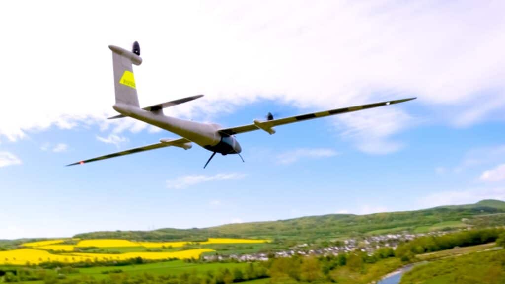
Fixed-wing drones, often recognized for their airplane-like design, stand out for their efficiency and capability in large operations. Unlike their multi-rotor counterparts, fixed-wing drones rely on the movement of air over their wings to provide lift, similar to traditional aircraft. This design gives them several advantages, particularly in large-scale and time-sensitive projects. Advantages of Fixed-Wing Drones: Accessibility: VTOL technology allows these drones to operate in varied and constrained environments where traditional fixed-wing drones could not. Efficiency: They combine the quick deployment and landing capabilities of multi-rotors with the long-range, high-speed flight of fixed wings, making them highly efficient. Versatility: Ideal for complex missions, including geographic mapping of rugged terrain and agricultural surveys over vast areas. Longer Flight Times: Fixed-wing drones are particularly beneficial for large-scale projects due to their longer flight times and ability to cover vast distances without the need to recharge. This capability means they can complete missions in a shorter period compared to other drone types, reducing labour and the need for multiple flights. Understanding VTOL One significant innovation in fixed-wing drones is VTOL (Vertical Take-Off and Landing) This technology combines the best of fixed-wing and rotor-based drone capabilities. VTOL allows fixed-wing drones to take off and land on the spot, much like a helicopter, eliminating the need for a runway. After ascending, they transition to horizontal flight, benefiting from the energy efficiency and speed of fixed-wing aerodynamics. Autonomy and Operation Fixed wing drones are often fully autonomous, capable of executing pre-planned missions with minimal human intervention. From take-off to data collection, and landing, every step can be automated, ensuring precision and consistency in data collection, which is crucial for scientific surveys, environmental monitoring, and large infrastructure projects. Sensor Technology Fixed-wing drones can also be equipped with a range of sensors to boost their capabilities: RGB Sensors: Similar to consumer cameras, these sensors capture images in red, green, and blue light. They are necessary for general photography and videography and play a key role in surveying and mapping by capturing detailed images of landscapes. LiDAR Sensors: LiDAR (Light Detection and Ranging) utilizes laser beams to measure distances to the Earth’s surface. These sensors are essential for producing precise three-dimensional maps and collecting accurate geographical data. Thermal Sensors: By detecting heat emitted from objects, thermal sensors are essential in locating people or animals in search and rescue missions, monitoring wildlife, and inspecting buildings to identify heat loss or potential issues. Multispectral Sensors: Primarily used in agriculture, these sensors gather data across multiple light bands to analyse plant health. This helps farmers optimize crop yields and minimize waste by monitoring light absorption and reflection. For more info on sensors, check out our article “Advanced Sensor Technology in Drones”, available here. Saving Time and Money Incorporating fixed-wing drones into commercial operations translates into significant savings in time and money. These drones are designed to handle extensive tasks efficiently, offering a return on investment that is attractive to industries spanning from agriculture to urban planning. Their ability to quickly gather data across large areas reduces the number of flights needed, thereby decreasing operational costs, and speeding up the time to insight. To see an example of a fixed wing drone and to learn more about what they can offer, check out the Quantum Systems Trinity Pro on our website. Fixed-wing drones, particularly those equipped with VTOL, are greatly improving how large-scale projects are managed and executed. By reducing both time and financial investments, these drones offer a powerful tool for businesses looking to boost efficiency and productivity. If you are exploring the potential of drones to advance your operations, our team at Drone Shop is here to assist. With our expertise, we can help you weigh up your options and find the most effective solution for your needs. Related Blogs
Drone Range and Battery Life Explained: How Far and Long Can You Fly?
Understanding the factors that impact drone range and battery life is crucial for making the output of your operations more efficient. Drone range refers to how far a drone can fly before it must return, while battery life determines how long it can stay in the air. Factors Affecting Range and Flight Time: Battery Capacity: Larger batteries provide longer flight times but may increase the drone’s weight. Weight: The heavier the drone, especially with added payloads, the more battery power it requires. Weather Conditions: Wind and temperature can significantly affect battery performance and has a big impact on flight range and duration. Flying Techniques: Efficient use of battery life also depends on the pilot’s ability to manage the drone’s speed and manoeuvring. Tips to Increase Drone Performance: Optimize Payloads: Use only necessary equipment to keep the drone’s weight optimal. Monitor Weather Conditions in Advance: Plan flights for optimal weather conditions to avoid high winds, rain, or extreme temperatures. Regular Maintenance: Keep your drone in good health with regular checks on battery health and propeller condition. Preventing Battery Over-Discharge and Extending Life Effective battery management is key to extending the life of your drone’s battery: Optimal Charge Levels for Storage: Discharge the battery to about 40%-65% if not in use for more than 10 days. Store in a cool, dry place at a recommended temperature between 22°C and 28°C. Routine Cycling: Fully charge and discharge the battery at least every three months to maintain capacity and performance. After charging, use the drone until it reaches about 65% capacity before storage. Storage and Maintenance: Store batteries in a well-ventilated area and recharge them if they fully deplete and enter hibernation to prevent permanent damage. Understanding Restrictions and Extending Flight Capabilities: In many regions, drone flight is restricted by regulations that may limit where and how long you can fly. However, it is possible to apply for permissions to extend these capabilities on a case-by-case basis. For instance, to increase the Trinity Pro’s flight time from 60 to 90 minutes, a detailed application must be submitted to the manufacturer, who will coordinate with the relevant authorities. This process can be time-consuming and is not guaranteed to result in approval. The laws in the UAE are subject to change and we do our best to keep our blog updated with the latest revisions to legislation, for more information and to stay up to date you can check out this article around UAE laws and regulations. If you require assistance with navigating these regulations or applying for extended flight capabilities, our expert team at Drone Shop is ready to help. Feel free to contact us to help ensure your drone missions are as efficient and compliant as possible. Related Blogs
How to Plan a Drone Mission: (Part 1) Pre-Flight Tips for Success
Welcome to the first installment in our two part series on “How To Plan a Drone Mission”, in this first article we will take you through a basic step by step guide on how to plan your mission successfully and safely. Make sure you stay up to date on our blog and follow us on our socials for updates on part two, where we will showcase these steps in a live drone mission with the Trinity Pro. Not to be missed! Planning a drone mission is a critical step that ensures the success and safety of your operations, especially for professional drone operators and commercial pilots. To navigate your next flight seamlessly, here are essential pre-flight tips that will prepare you for any aerial challenge. Understand Your Mission Objectives Before any flight, clearly define what you need to achieve. Whether it’s surveying, inspection, or aerial photography, having clear objectives helps you plan the flight path and choose the right equipment and settings. Check the Weather Weather can significantly impact drone performance. Always check the forecast for wind, rain, and temperature for the planned time of your flight. High winds can destabilize your drone, while rainfall can damage its electronic components. Review Local Flight Regulations The UAE has specific regulations concerning drone flights. Make sure you are up to date with the local laws to avoid legal issues. This includes no-fly zones, altitude restrictions, and any special permits and permissions required for the area. Select Appropriate Mapping Software Choose a mapping software that fits the mission’s needs. For detailed surveys, software with advanced analytical tools and high-resolution output is essential. Seek help from a professional and/or familiarise yourself with the software beforehand to ensure it runs smoothly during the mission. Run Through a Pre-Flight Checklist Always run through a pre-flight checklist before take-off. Check the drone’s battery levels, propeller condition, camera settings, and GPS functionality. This will help identify any issues that might interfere with the mission. Plan for Emergencies Have a contingency plan ready in case of unexpected events such as sudden weather changes or technical failures. Know where you can safely land and ensure your drone’s return-to-home feature is correctly set up. Conduct a Site Survey If possible, visit the site beforehand or use satellite imagery to understand the terrain and identify potential obstacles. This will help in planning a safe and efficient flight path. With these pre-flight preparations to hand, you’re now well on your way to conduct a successful drone mission. By carefully planning each step, you not only increase the safety of your operation but also the quality of the data collected. If you’re looking for expert guidance or need assistance with obtaining the necessary permits and licenses for your drone operations, our team at Drone Shop is here to help. Contact us today to ensure your next drone mission is a success! Related Blogs
How to Get Certified as a Commercial Drone Pilot

Becoming a certified commercial drone pilot is an essential step for anyone looking to use drones for business purposes. The certification process ensures you understand the safety protocols, legal requirements, and operational standards necessary to fly drones commercially. Here is a simplified guide on how to obtain the necessary certifications, register your drone, and understand the implications of non-compliance. Understand the Certification Requirements Start by familiarising yourself with the certification requirements relevant to your operation. This typically involves passing a knowledge test that covers local laws, operation procedures, navigation, and drone specifics. The exact details can vary, so it is crucial to consult your local aviation authority’s website for the most accurate information. If you are based in the UAE, for Dubai this is the DCAA, for other Emirates you can contact the GCAA. Choose a Training Program Enrol in an accredited GCAA or DCAA drone pilot training program. These courses are crafted to prepare you for the official certification exam and often offer practical flight training, which can be invaluable. (This is something we can assist with at Drone Shop, for more information on this, visit this link) Pass the Certification Exam After completing your training, you will need to pass a certification exam. This test will typically be administered by the national aviation authority or an approved testing centre. Passing this exam demonstrates your competence in both the theoretical and practical aspects of drone operation. Register Your Drone Once certified, the next step is to register your drone with the relevant authorities. This registration typically requires providing details about your drone, including the make, model, serial number, and proof of insurance. Registration is crucial as it helps in the accountability and management of drones in national airspace. Understand the Consequences of Non-Compliance Operating a drone without proper certification or failing to register your drone can lead to significant penalties, including fines and legal action. It is also likely to restrict your opportunities for commercial drone use in the future. Stay Updated Drone regulations are continuously evolving as the technology, and its applications develop. It is important to stay informed about any changes to the laws that might affect your operations. By following these steps, you can ensure that you meet all legal requirements and are fully prepared to commence commercial drone operations. Keep in mind that drone regulations are subject to change, so it is wise to stay connected with experts who can provide guidance and updates. If you need assistance or have any questions about getting certified or registering your drone, our team at Drone Shop is here to help. Keep an eye on our blog for the latest industry updates, make sure you follow us on LinkedIn and Instagram, and feel free to reach out to us for advice if you want to make sure you are up to date and flying safely and legally. Related Blogs
2025 Update: UAE Announce Changes To Recreational Drone Use
The UAE has recently updated its drone regulations, allowing for recreational drone use across the Emirates, however please take note – this does not apply to Dubai. This regulatory shift is a significant development for those interested in aerial photography and recreational flying outside of Dubai’s jurisdiction. For hobbyist/recreational drone pilots in the other Emirates, here’s a straightforward guide on how to get your drone registered: Requirements for Registration: Applicants must be 16 years or older. A drone training certificate from a GCAA accredited center is required. Adherence to the General Civil Aviation Authority (GCAA) guidelines is essential. The drone must weigh under 5kg. Documents needed include a passport and visa copy, a recent 3×3.5cm color photograph against a white background, Emirates ID, and a pilot training certificate from a local authority. Steps to Register Your Drone: Go to drones.gov.ae, the official registration site. Log in with UAE Pass or sign up for an account. Returning users can enter their existing credentials. New users with UAE Pass must choose between ‘Recreational’ and ‘Commercial’ during setup. Enter your personal details such as name and passport number. Upload the necessary documents. Agree to the terms and conditions, submit your form, and wait for GCAA approval, typically within five business days. Once approved, a payment link for the registration fee is sent via email. Registration Costs: A Dh200 fee is required for the initial registration certificate. Renewal every two years also costs Dh200. At Drone Shop, we specialize in supporting professional drone operators and commercial pilots. If you’re looking to secure permits and licenses for commercial drone operations in Dubai or anywhere across the UAE, our expert team is ready to assist you. Let us help you streamline your registration process so you can focus on flying safely and efficiently. Drone Regulations & permits Frequently Asked Questions Most frequent questions and answers How do I obtain commercial drone flying permit in the UAE? Applications go through the General Civil Aviation Authority and Ministry of Defence, requiring both the operator and the drone to be registered through a mainland UAE company that has been security checked by the GCAA and MoD Where is drone flying prohibited in the UAE? Drone flying is restricted near airports, in densely populated urban areas, and around sensitive government structures. What insurance do I need to operate a drone commercially? Commercial operators must secure liability insurance covering potential damages from drone operations. Are the any consequences for not having the correct permissions? Yes, fines are applicable and depending on the outcome of the data captured heavier punishment can be applied by local authorities.
YellowScan: All You Need To Know

YellowScan LiDAR scanners have become a major player in aerial mapping and surveying, offering precision and efficiency across various industries. With advanced LiDAR technology, these scanners provide reliable solutions for professionals working in fields like forestry, archaeology, and infrastructure monitoring. https://droneshop.ae/wp-content/uploads/2024/12/YellowScan-Video-1.mp4 What Are YellowScan Scanners Used For? YellowScan specializes in creating LiDAR (Light Detection and Ranging) scanners which can be integrated to different drone platforms. These scanners are designed to gather detailed, accurate data for mapping and surveying tasks. Founded with a focus on making data collection easier and more effective, the company has built a reputation for quality and reliability. YellowScan’s LiDAR Models YellowScan Mapper: Designed for general mapping needs, offering exceptional accuracy and reliability. YellowScan Surveyor: Perfect for high-precision tasks in challenging environments. YellowScan Explorer: Ideal for long-range missions, balancing performance and efficiency. YellowScan Navigator: Bathymetric scanner that covers both land and underwater data sets. How These Scanners Are Used: Environmental Mapping These scanners help monitor ecosystems, measure tree density, and track changes in the environment. Infrastructure Assessment Ideal for inspecting roads, bridges, and power lines, they make it easier to spot potential issues. Mining and Quarrying They provide accurate measurements of stockpiles and aid in terrain analysis, helping businesses plan more effectively. Archaeological Surveys By identifying structures buried beneath vegetation, they assist researchers in uncovering historical sites without digging. Mobile Mapping The Surveyor Ultra is one of YellowScan’s most versatile scanners as it can be mounted on a drone and then simply detached and placed into their POD on a car to continue mapping from the road. How Does LiDAR Technology Work? LiDAR technology uses laser pulses to measure distances and create 3D maps. Unlike traditional methods, LiDAR can capture data in dense environments like forests or rugged terrain. Mounted on drones, this technology allows professionals to complete surveys quickly and accurately, saving time and resources. Features That Make YellowScan Scanners Stand Out Compact and Lightweight The LiDAR scanners are easy to transport and suitable for use in remote areas, making them perfect for on-site operations. Real-Time Data Collection They allow users to review collected data immediately, speeding up decision-making. Compatibility YellowScan scanners work with a variety of UAV platforms, giving users flexibility in their operations. Choosing YellowScan: What Sets Them Apart YellowScan is widely recognized for its focus on LiDAR technology. Their scanners are specifically built for professional use, with robust support and training programs available to users. This makes them a trusted choice for those needing precise and dependable data collection. Whether you’re tackling environmental studies, infrastructure inspections, underwater mapping or large-scale projects, YellowScan scanners can make all the difference. At Drone Shop our team of experts are here to provide tailored support, from operational advice to hands-on training, ensuring you achieve the best results for your project. Ready to take your project to the next level? You can check out the full range of YellowScan products here. Related Blogs
Using LiDAR with Drones for Better Mapping and Data Collection
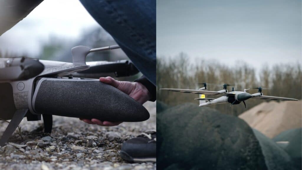
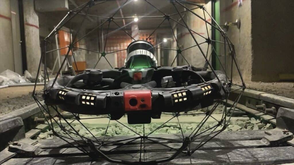
LiDAR technology combined with drones is changing the game in how we gather detailed environmental and geographical data. This powerful duo is especially useful in areas that are tough to reach or unsafe for people. In our latest blog, we’ll explore both LiDAR scanners and LiDAR drones in detail. In particular we will deep dive into how drones equipped with LiDAR are used in different fields, their benefits, and look at some of the top scanners and drones on the market today. LiDAR – Sounds Cool, But What is it? LiDAR stands for Light Detection and Ranging. It is a remote sensing method that uses light in the form of a pulsed laser to measure distances to the ground. These light pulses when combined with other data (typically recorded by a drone) generate precise, three-dimensional information about the shape of terrain and its surface characteristics. LiDAR technology is especially useful for mapping and surveying, providing detailed and accurate landscape data quickly and efficiently. When drones for mapping are installed with this technology the results are generally far superior. Main Uses for LiDAR LiDAR drones are incredibly versatile and used widely in industries like urban planning, agriculture, and environmental monitoring. Urban planners use them for creating detailed city models and planning infrastructure projects accurately. In agriculture, LiDAR drones help with land surveying and improving farming techniques by analysing soil conditions and crop health. Environmental scientists also rely on these drones to monitor natural habitats, track erosion, and study geological formations, providing essential data for conservation efforts. Key Benefits of LiDAR Combining LiDAR with drones brings several advantages: Precision and Accuracy: LiDAR sensors deliver precise measurements, crucial for making detailed 3D maps of surveyed areas. Access to Tough Spots: Drones can fly into areas that are hard or dangerous to reach, reducing risks for survey teams. Quick Data Collection: Covering large areas quickly, LiDAR drones gather data much faster than traditional methods. Cost Savings: Although they’re an investment, LiDAR drones reduce the overall cost of large survey projects and ongoing monitoring. Top LiDAR Products On The Market First up, lets discuss LiDAR Scanners, introducing…. YellowScan YellowScan YellowScan’s cutting-edge LiDAR technology is expertly designed for integration with drones, supporting not only precise 3D mapping but also advanced bathymetric and mobile mapping capabilities. This versatility allows for the detailed capture of both terrestrial and underwater environments, making it ideal for a variety of applications such as geological surveys, forestry, and environmental monitoring. The scanners are renowned for their lightweight build and high accuracy, ensuring that professionals can efficiently gather topographic data and valuable insights with less time spent in the field. By incorporating mobile mapping, YellowScan also enables dynamic data collection on the move, further enhancing productivity and the quality of data across different settings. This comprehensive approach sets new standards in both aerial and aquatic surveying. Let’s take a look at some standout LiDAR drones that are leading the pack: Flyability Elios 3: This drone is specifically engineered for navigating and inspecting tight and complex spaces, making it an ideal tool for indoor environments and intricate infrastructures. It excels in performing detailed inspections where precision is paramount. With the recent enhancement of its LiDAR payload, the Elios 3 now offers advanced capabilities for scanning and mapping internal spaces. This upgrade significantly improves the drone’s utility in creating highly accurate and detailed models, essential for Building Information Modelling (BIM). These features not only streamline the inspection process but also enhance safety by minimizing the need for human entry into potentially hazardous areas. This makes the Elios 3 a top choice for industries looking to optimize their maintenance routines and infrastructure management through cutting-edge aerial technology. Quantum Systems Trinity Pro: Known for its extended flight durations and exceptional reliability, the Trinity Pro drone excels in geographic mapping and agricultural applications, making it ideally suited for managing large-scale tasks with remarkable efficiency. Equipped with a variety of sensor options, the Trinity Pro can be tailored to meet the specific demands of different projects, ensuring optimal performance for any task. This adaptability, coupled with its robust performance, makes the Trinity Pro a prime choice for professionals seeking a dependable drone capable of precise, extensive data collection across diverse environments. Additionally, its enhanced battery life and user-friendly interface facilitate longer operational periods and easier control, further increasing its utility in complex and time-sensitive operations. This combination of features solidifies the Trinity Pro’s status as a top-tier tool in the field of advanced aerial surveying. What Does the Future Hold? LiDAR drones are proving to be indispensable in a variety of fields, transforming the way we map, inspect, monitor, and manage our environment. They offer a combination of efficiency, safety, and precision that’s impossible to beat. Whether you’re managing a construction site, inspecting overhead powerlines, planning a new city area, or monitoring environmental changes, using LiDAR with drones is becoming an essential part of successful operations. With the latest developments in LiDAR technology, you can achieve more accurate and efficient results in your projects. If you found this information useful and have any questions or need more details about using LiDAR-equipped drones like the Trinity Pro or Elios 3, feel free to contact our team at Drone Shop. We’re here to provide the support you need to effectively incorporate this technology into your operations. Related Blogs
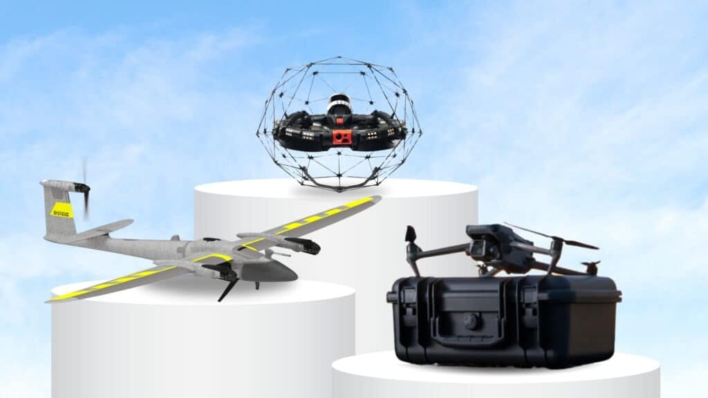
INFOGRAPHIC: 2025 Top Drones for Commercial Use

Download PDF Download JPG Top Commercial Drones to Watch in 2025 This fresh lineup for 2025 highlights cutting-edge advancements in drone technology. Featured models include the Flyability Elios 3 & Quantum Systems Trinity Pro (which both utilize LiDAR technology); then we also have the Autel Evo Max 4N, DJI Matrice 350 RTK, and the DJI Mavic 3 Enterprise, setting new benchmarks in the commercial drone industry. You can find each of these drones on the links above or if you wish to speak to one of our team you can do that by clicking here.
Drone Regulations in the UAE: A Guide for Pilots and Businesses
Click Here To Read The Latest Hobbyist Update August 2025 Introduction to Drone Regulations in the UAE The UAE stands out as a global leader in the adoption and regulation of drone technology, offering a comprehensive legal framework that ensures the safe operation of drones within its airspace. As drones become more and more popular in commercial activities and recreational interests, understanding the local regulations is crucial for anyone operating in this space. In this article we will outline the key aspects of drone regulations in the UAE, helping pilots and businesses to ensure they are compliant and don’t fall foul of the law. New Changes for 2025 Latest GCAA Rule Update From January 2025, new drone regulations will apply across the UAE. You will no longer be allowed to fly in GCAA-regulated areas unless you have completed certified drone training through an officially GCAA-approved academy. This applies to all drone operators, including those flying for recreational or commercial purposes. At Drone Shop, we are on hand to help you start your drone pilot training, obtain your drone training certificate, and access beginner-friendly drone flying courses through GCAA-certified trainers. Before you can begin any training, you will need to get a security clearance certificate – this is a legal requirement and usually takes around 3 to 4 weeks to complete. We can guide you through this step as part of the training process. To stay informed as regulations change, we strongly recommend downloading and regularly checking the Drones UAE app, which provides real-time updates on approved flying zones and the latest drone rules across the UAE. While we do our best to offer accurate guidance, Drone Shop cannot be held responsible for any outdated or incorrect information – always refer to the official Drones UAE app before flying. DCAA has implemented two new changes to the flight permit application process: Anyone looking to obtain permits to fly drones must have a Dubai trade license to be able to apply. For NOTAMS, DANS have taken over the process of doing this for flights with exceptional circumstances like higher flight height or restricted flight zones. The normal DCAA process is still in place, but you now need DANS NOC to be able to fly drones in exceptional circumstances. Registration and Licensing In the UAE, the registration of drones is mandatory for both recreational and commercial users, whether you are looking to carry out drone inspections, surveying and mapping or aerial photography. This process is managed by the General Civil Aviation Authority (GCAA), which requires all UAVs to be registered with them and pilots to obtain the appropriate licenses before operating the drones. For commercial operations, additional permits are usually required, first from the MOD (Ministry of Defence) as well as clearance from the local authority depending on which Emirate you are in (a list of these below.) The permit process typically involves providing detailed operation plans and undergoing safety assessments. The process of obtaining the permits generally takes around 14 working days. Local Civil Aviation Authorities in the UAE: DCAA (Dubai Civil Aviation Authority) ADCA (Abu Dhabi Civil Aviation Authority) DCA (Department of Civil Aviation Sharjah) FIA (Fujairah International Airport) RAK Airport (Ras Al Khaimah) Contact Us To Discuss Obtaining Your Commercial Drone License Leave your details and one of our team will be in touch! Flight Restrictions and No-Fly Zones The UAE enforces specific flight restrictions to maintain safety and security. The flying of drones in and around airports, government buildings, and military installations is restricted. Furthermore, the UAE has designated ‘no-fly zones,’ which are clearly marked and updated regularly on the GCAA’s official website. Attempting to fly drones in these areas without the correct permits can lead to significant punishments, including fines and potential criminal charges which can include jail time. Safety Guidelines Safety is a top priority in the UAE drone regulations. Drone pilots are required to always keep their drones within the visual line of sight and should not exceed a certain altitude, (typically max 400 feet above ground level.) Night flying is also restricted unless the operator has received specific approval and the drone is equipped with the necessary lighting. Pilots are also advised to avoid areas with large crowds and to maintain a safe distance from other aircraft, people, and private properties. Certain types of drones such as fixed-wing drones and UAV’s may also need special permissions depending on what they are being used for and where. Insurance and Liability For commercial drone operators, securing insurance is another important aspect of compliance. This is of particular importance if you are using drones for construction. UAE law requires liability insurance for commercial drones, which protects against potential damages or injuries caused by drone operations. This requirement emphasises the importance of responsible flying and ensures that businesses are covered in case of accidents. Training and Education Staying informed about the latest regulations is essential for compliance. The GCAA offers training programs and resources that are invaluable for both new and experienced drone operators. These resources include updates on legislation changes, safety workshops, and conferences for advanced drone operations. Participating in these educational opportunities is highly recommended if this is a subject you want to stay at the forefront of. Drone Shop can assist with any training needs you may have, which take place at local commercial drone training facilities. International Comparison of Drone Regulations The UAE enforces strict drone regulations emphasizing safety and privacy, aligning more closely with the EU’s approach than the U.S. In Europe, drone operations are tightly regulated with a strong focus on privacy, whereas in the U.S., regulations are more accommodating to recreational use. This comparison highlights the UAE’s commitment to safe and regulated drone use, particularly around residential zones and built up areas. We hope you found this useful Navigating drone regulations in the UAE requires a thorough knowledge of the do’s and don’ts and a no-nonsense approach to compliance. By adhering to the rules, following safety guidelines and securing the appropriate insurance,
Explore the Future: Drone Shop at Geo World – LiveableCitiesX 2024
Join Drone Shop at the upcoming Geo World event, part of LiveableCitiesX 2024, a one of a kind gathering for those in geospatial technology and urban planning. This event will be held from November 26 to 28, 2024, at the Dubai World Trade Centre. We are excited to be located in Za’abeel Hall 6 at Stand Z6 F41, alongside our partners YellowScan, producers of advanced LiDAR scanners for drones, and Quantum Systems, creators of the popular Trinity Pro drone. Event Details Event Name: Geo World as part of LiveableCitiesX 2024 Dates: November 26-28, 2024 Location: Dubai World Trade Centre, Za’abeel Hall 6 Drone Shop Stand: Z6 F41 Event Hours: 10:00 – 18:00 hrs daily RSVP FOR THE EVENT HERE! About Geo World Geo World is the prime venue for professionals to deepen their knowledge of geospatial technologies through hands-on experiences and engaging discussions. Attendees will have the opportunity to: Hear insights from global and regional experts. Explore the latest innovations in geospatial technology. Discover new products and see cutting-edge technology before it hits the market. Connect with industry leaders, meet potential suppliers and partners. Participate in discussions that are shaping the future of liveable cities. Gain actionable insights and ideas that span across various industries. Why Visit Drone Shop at Geo World? At our stand, visitors will experience the synergy between Drone Shop, YellowScan, and Quantum Systems, showcasing how our combined technologies enhance urban planning and environmental monitoring. You will get the chance to see the drones in person and sign up for our live demonstration which will highlight the capabilities of the Trinity Pro Fixed Wing Drone equipped with YellowScan’s LiDAR technology. This demo will take place after the event and will be illustrating the practical applications and benefits for industries such as construction, agriculture, and disaster management. Meet the Experts A unique opportunity to meet our experts in person. Experience our technology up close. This hands-on experience allows you to touch and interact with the technology while receiving a detailed explanation of how it works, providing a deeper understanding of the practical applications and benefits of our integrated solutions. Don’t miss this chance to have your questions answered directly by those who know our products best. Networking Opportunities Geo World provides an unparalleled platform for networking with innovators, decision-makers, and influencers in the geospatial and urban planning sectors. Forge new connections, discuss potential collaborations, and discover how to leverage these technologies to advance your projects. RSVP FOR THE EVENT HERE! Geo World is an unmissable event for professionals eager to push the boundaries of what’s possible in geospatial technology and urban development. Come and say hello to the Drone Shop team at Stand Z6 F41 in Za’abeel Hall 6 to explore how our advanced drone solutions powered by our partners YellowScan and Quantum Systems can transform your operations. We look forward to meeting you and helping you integrate these technologies to take your processes to the next level.