Why The Flyability Elios 3 Is A Smart Choice For Your Business

Inspections are often required in spaces that are difficult to navigate. Whether it’s limited space, unstable ground, or a safety concern, reaching certain areas on-site can quickly become a challenge – and a costly, time consuming one at that.This is where the Flyability Elios 3 stands out. It’s built to support teams working in complex environments, helping them carry out inspections without needing to send people into potentially risky or restricted areas. When time, safety, and access are all critical factors, having a reliable tool that can get eyes on hard-to-reach places can make a real difference to how a task is completed. A More Efficient Way Of Working Thanks to its collision-tolerant cage, the Elios 3 can fly close to assets and structures without the risk of damage, even in tight, cluttered spaces, and with its unique ability to operate in GPS-denied environments – including underground, inside tanks, or within complex facilities – this drone removes many of the constraints associated with traditional inspections. Flight times of up to 12 minutes, combined with hot-swappable batteries and fast set up and deployment, mean teams can complete thorough inspections in less time. The drone’s powerful onboard lighting and 4K camera provide high-resolution visuals, reducing the need for repeated flights and costly second guesses. For businesses, this means fewer shutdowns, faster decision-making, and better use of resources – all of which add up to a smarter, more cost-effective way of working. Technology That Supports Your Team The Elios 3 is designed to make complex inspection work more manageable – giving teams the tools they need to navigate confined, high-risk environments with greater control and confidence. At its core is FlyAware™, Flyability’s real-time navigation system that combines LiDAR and computer vision to generate a live 3D map during flight. This gives operators a clear view of their surroundings and progress, helping them stay oriented and ensure full inspection coverage. Data is displayed clearly in the Cockpit app throughout the flight, and once the job is done, teams can review footage, extract images, and create reports using Inspector 4.0 – keeping the entire process efficient, from planning to post-inspection. Payload Options That Adapt to Your Needs The Elios 3 features a modular payload bay with two dedicated ports – one for LiDAR and one for auxiliary payloads – giving teams the flexibility to adapt the drone to different missions and environments. For detailed spatial data, the Surveying Payload delivers high-precision LiDAR, ideal for 3D modelling, structural mapping, and inspections in inaccessible areas. It supports a range of industries where accurate visuals and measurement are essential. For more specialised use cases, the RAD Payload enables remote radiation detection and localisation, allowing teams to assess hazardous environments without direct exposure -particularly valuable in nuclear facilities and decommissioning projects. The Flyability Elios 3 UT is the latest payload that turns the Elios 3 drone into a flying ultrasonic thickness gauge. It provides accurate thickness measurements with high-resolution scans in even the toughest environments. Easily mounted on the top, front, or bottom of the drone, this adaptable tool allows industry professionals to perform quick, reliable integrity inspections. Interested To Find Out More? The Elios 3 isn’t just a high-tech drone – it’s a practical tool built to handle the real-world challenges of industrial inspection. From navigating confined spaces to delivering accurate, actionable data, it supports teams in working more safely, efficiently, and with greater confidence. With its modular design, intelligent navigation, and expanding range of payloads, it’s a system that adapts to your needs – not the other way around. Whether you’re taking your first steps into drone-based inspection or looking to upgrade your existing capabilities, the Elios 3 offers a reliable, future-ready solution. If you’re exploring options for indoor inspection, we’d be happy to help you understand how the Elios 3 fits into your operation! Related Blogs
How Drone Software Enhances Operational Efficiency
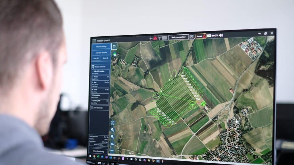
In this blog, we’ll look at the different types of software that make drones more useful. Whether it’s for drawing maps, planning flights, or analysing photos, these programs help get the most out of every flight. Mapping Software Facilitates the creation of detailed maps and 3D models from aerial images, crucial for sectors like agriculture, construction, and real estate. This software is fundamental in transforming high-resolution aerial images into detailed topographic maps and 3D models. It is invaluable in industries requiring precise geographical data, such as agriculture, construction, and urban planning. By streamlining data collection, mapping software reduces the need for extensive manual surveys, saving time and resources. Analytics Tools Processes data from drone flights to provide actionable insights, vital for optimizing operations in fields such as agriculture for crop health monitoring or infrastructure for progress tracking. Utilizing these tools, drone operators can harness complex data for practical applications, streamlining workflows and boosting the accuracy of outcomes. This level of analysis is indispensable for sectors that rely heavily on precise and timely data, from environmental monitoring to urban planning. Flight Planning Tools Enables precise route planning based on factors like terrain, weather, and regulatory restrictions, ensuring efficient and safe flights. Critical for operational planning, flight planning software ensures that drones operate within safe and legal parameters. It helps operators plan flights that maximize battery efficiency and coverage area while adhering to no-fly zones and weather conditions. This not only helps in avoiding potential hazards but also ensures compliance with aviation regulations. Most drones come with their own specific software, but there are third party software’s out there that can be used as well for different projects. 3D Modelling Tools Enhances the ability to create complex, detailed three-dimensional representations of captured data, ideal for industries requiring precision modelling like architecture and urban planning. 3D modelling software provides a deeper level of detail in visualizations, allowing professionals to create precise models of physical spaces. This capability is particularly useful in construction, architecture, and heritage preservation, where accurate 3D representations are essential for planning and documentation. Notable software brands in these categories include Bentley, Pix4D, and AgiSoft, which are well-recognized within the industry for their capabilities in processing and modelling complex data sets. Each type of software plays a pivotal role in maximizing the effectiveness and safety of drone operations. We hope you found this article useful, for personalized advice on integrating drone software into your operations, or for recommendations on the best tools for your specific needs, our experts are ready to assist. Contact us today to streamline your drone operations and enhance your operational capabilities. Related Blogs
What Are Fixed-Wing Drones & When Should You Use Them?
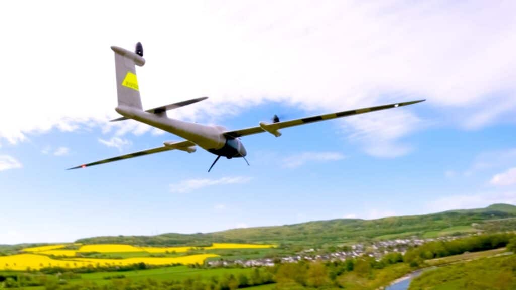
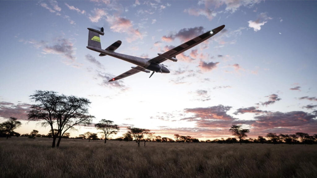
Fixed-wing drones, often recognized for their airplane-like design, stand out for their efficiency and capability in large operations. Unlike their multi-rotor counterparts, fixed-wing drones rely on the movement of air over their wings to provide lift, similar to traditional aircraft. This design gives them several advantages, particularly in large-scale and time-sensitive projects. Advantages of Fixed-Wing Drones: Accessibility: VTOL technology allows these drones to operate in varied and constrained environments where traditional fixed-wing drones could not. Efficiency: They combine the quick deployment and landing capabilities of multi-rotors with the long-range, high-speed flight of fixed wings, making them highly efficient. Versatility: Ideal for complex missions, including geographic mapping of rugged terrain and agricultural surveys over vast areas. Longer Flight Times: Fixed-wing drones are particularly beneficial for large-scale projects due to their longer flight times and ability to cover vast distances without the need to recharge. This capability means they can complete missions in a shorter period compared to other drone types, reducing labour and the need for multiple flights. Understanding VTOL One significant innovation in fixed-wing drones is VTOL (Vertical Take-Off and Landing) This technology combines the best of fixed-wing and rotor-based drone capabilities. VTOL allows fixed-wing drones to take off and land on the spot, much like a helicopter, eliminating the need for a runway. After ascending, they transition to horizontal flight, benefiting from the energy efficiency and speed of fixed-wing aerodynamics. Autonomy and Operation Fixed wing drones are often fully autonomous, capable of executing pre-planned missions with minimal human intervention. From take-off to data collection, and landing, every step can be automated, ensuring precision and consistency in data collection, which is crucial for scientific surveys, environmental monitoring, and large infrastructure projects. Sensor Technology Fixed-wing drones can also be equipped with a range of sensors to boost their capabilities: RGB Sensors: Similar to consumer cameras, these sensors capture images in red, green, and blue light. They are necessary for general photography and videography and play a key role in surveying and mapping by capturing detailed images of landscapes. LiDAR Sensors: LiDAR (Light Detection and Ranging) utilizes laser beams to measure distances to the Earth’s surface. These sensors are essential for producing precise three-dimensional maps and collecting accurate geographical data. Thermal Sensors: By detecting heat emitted from objects, thermal sensors are essential in locating people or animals in search and rescue missions, monitoring wildlife, and inspecting buildings to identify heat loss or potential issues. Multispectral Sensors: Primarily used in agriculture, these sensors gather data across multiple light bands to analyse plant health. This helps farmers optimize crop yields and minimize waste by monitoring light absorption and reflection. For more info on sensors, check out our article “Advanced Sensor Technology in Drones”, available here. Saving Time and Money Incorporating fixed-wing drones into commercial operations translates into significant savings in time and money. These drones are designed to handle extensive tasks efficiently, offering a return on investment that is attractive to industries spanning from agriculture to urban planning. Their ability to quickly gather data across large areas reduces the number of flights needed, thereby decreasing operational costs, and speeding up the time to insight. To see an example of a fixed wing drone and to learn more about what they can offer, check out the Quantum Systems Trinity Pro on our website. Fixed-wing drones, particularly those equipped with VTOL, are greatly improving how large-scale projects are managed and executed. By reducing both time and financial investments, these drones offer a powerful tool for businesses looking to boost efficiency and productivity. If you are exploring the potential of drones to advance your operations, our team at Drone Shop is here to assist. With our expertise, we can help you weigh up your options and find the most effective solution for your needs. Related Blogs
YellowScan: All You Need To Know

YellowScan LiDAR scanners have become a major player in aerial mapping and surveying, offering precision and efficiency across various industries. With advanced LiDAR technology, these scanners provide reliable solutions for professionals working in fields like forestry, archaeology, and infrastructure monitoring. https://droneshop.ae/wp-content/uploads/2024/12/YellowScan-Video-1.mp4 What Are YellowScan Scanners Used For? YellowScan specializes in creating LiDAR (Light Detection and Ranging) scanners which can be integrated to different drone platforms. These scanners are designed to gather detailed, accurate data for mapping and surveying tasks. Founded with a focus on making data collection easier and more effective, the company has built a reputation for quality and reliability. YellowScan’s LiDAR Models YellowScan Mapper: Designed for general mapping needs, offering exceptional accuracy and reliability. YellowScan Surveyor: Perfect for high-precision tasks in challenging environments. YellowScan Explorer: Ideal for long-range missions, balancing performance and efficiency. YellowScan Navigator: Bathymetric scanner that covers both land and underwater data sets. How These Scanners Are Used: Environmental Mapping These scanners help monitor ecosystems, measure tree density, and track changes in the environment. Infrastructure Assessment Ideal for inspecting roads, bridges, and power lines, they make it easier to spot potential issues. Mining and Quarrying They provide accurate measurements of stockpiles and aid in terrain analysis, helping businesses plan more effectively. Archaeological Surveys By identifying structures buried beneath vegetation, they assist researchers in uncovering historical sites without digging. Mobile Mapping The Surveyor Ultra is one of YellowScan’s most versatile scanners as it can be mounted on a drone and then simply detached and placed into their POD on a car to continue mapping from the road. How Does LiDAR Technology Work? LiDAR technology uses laser pulses to measure distances and create 3D maps. Unlike traditional methods, LiDAR can capture data in dense environments like forests or rugged terrain. Mounted on drones, this technology allows professionals to complete surveys quickly and accurately, saving time and resources. Features That Make YellowScan Scanners Stand Out Compact and Lightweight The LiDAR scanners are easy to transport and suitable for use in remote areas, making them perfect for on-site operations. Real-Time Data Collection They allow users to review collected data immediately, speeding up decision-making. Compatibility YellowScan scanners work with a variety of UAV platforms, giving users flexibility in their operations. Choosing YellowScan: What Sets Them Apart YellowScan is widely recognized for its focus on LiDAR technology. Their scanners are specifically built for professional use, with robust support and training programs available to users. This makes them a trusted choice for those needing precise and dependable data collection. Whether you’re tackling environmental studies, infrastructure inspections, underwater mapping or large-scale projects, YellowScan scanners can make all the difference. At Drone Shop our team of experts are here to provide tailored support, from operational advice to hands-on training, ensuring you achieve the best results for your project. Ready to take your project to the next level? You can check out the full range of YellowScan products here. Related Blogs
Using LiDAR with Drones for Better Mapping and Data Collection
LiDAR technology combined with drones is changing the game in how we gather detailed environmental and geographical data. This powerful duo is especially useful in areas that are tough to reach or unsafe for people. In our latest blog, we’ll explore both LiDAR scanners and LiDAR drones in detail. In particular we will deep dive into how drones equipped with LiDAR are used in different fields, their benefits, and look at some of the top scanners and drones on the market today. LiDAR – Sounds Cool, But What is it? LiDAR stands for Light Detection and Ranging. It is a remote sensing method that uses light in the form of a pulsed laser to measure distances to the ground. These light pulses when combined with other data (typically recorded by a drone) generate precise, three-dimensional information about the shape of terrain and its surface characteristics. LiDAR technology is especially useful for mapping and surveying, providing detailed and accurate landscape data quickly and efficiently. When drones for mapping are installed with this technology the results are generally far superior. Main Uses for LiDAR LiDAR drones are incredibly versatile and used widely in industries like urban planning, agriculture, and environmental monitoring. Urban planners use them for creating detailed city models and planning infrastructure projects accurately. In agriculture, LiDAR drones help with land surveying and improving farming techniques by analysing soil conditions and crop health. Environmental scientists also rely on these drones to monitor natural habitats, track erosion, and study geological formations, providing essential data for conservation efforts. Key Benefits of LiDAR Combining LiDAR with drones brings several advantages: Precision and Accuracy: LiDAR sensors deliver precise measurements, crucial for making detailed 3D maps of surveyed areas. Access to Tough Spots: Drones can fly into areas that are hard or dangerous to reach, reducing risks for survey teams. Quick Data Collection: Covering large areas quickly, LiDAR drones gather data much faster than traditional methods. Cost Savings: Although they’re an investment, LiDAR drones reduce the overall cost of large survey projects and ongoing monitoring. Top LiDAR Products On The Market First up, lets discuss LiDAR Scanners, introducing…. YellowScan YellowScan YellowScan’s cutting-edge LiDAR technology is expertly designed for integration with drones, supporting not only precise 3D mapping but also advanced bathymetric and mobile mapping capabilities. This versatility allows for the detailed capture of both terrestrial and underwater environments, making it ideal for a variety of applications such as geological surveys, forestry, and environmental monitoring. The scanners are renowned for their lightweight build and high accuracy, ensuring that professionals can efficiently gather topographic data and valuable insights with less time spent in the field. By incorporating mobile mapping, YellowScan also enables dynamic data collection on the move, further enhancing productivity and the quality of data across different settings. This comprehensive approach sets new standards in both aerial and aquatic surveying. Let’s take a look at some standout LiDAR drones that are leading the pack: Flyability Elios 3: This drone is specifically engineered for navigating and inspecting tight and complex spaces, making it an ideal tool for indoor environments and intricate infrastructures. It excels in performing detailed inspections where precision is paramount. With the recent enhancement of its LiDAR payload, the Elios 3 now offers advanced capabilities for scanning and mapping internal spaces. This upgrade significantly improves the drone’s utility in creating highly accurate and detailed models, essential for Building Information Modelling (BIM). These features not only streamline the inspection process but also enhance safety by minimizing the need for human entry into potentially hazardous areas. This makes the Elios 3 a top choice for industries looking to optimize their maintenance routines and infrastructure management through cutting-edge aerial technology. Quantum Systems Trinity Pro: Known for its extended flight durations and exceptional reliability, the Trinity Pro drone excels in geographic mapping and agricultural applications, making it ideally suited for managing large-scale tasks with remarkable efficiency. Equipped with a variety of sensor options, the Trinity Pro can be tailored to meet the specific demands of different projects, ensuring optimal performance for any task. This adaptability, coupled with its robust performance, makes the Trinity Pro a prime choice for professionals seeking a dependable drone capable of precise, extensive data collection across diverse environments. Additionally, its enhanced battery life and user-friendly interface facilitate longer operational periods and easier control, further increasing its utility in complex and time-sensitive operations. This combination of features solidifies the Trinity Pro’s status as a top-tier tool in the field of advanced aerial surveying. What Does the Future Hold? LiDAR drones are proving to be indispensable in a variety of fields, transforming the way we map, inspect, monitor, and manage our environment. They offer a combination of efficiency, safety, and precision that’s impossible to beat. Whether you’re managing a construction site, inspecting overhead powerlines, planning a new city area, or monitoring environmental changes, using LiDAR with drones is becoming an essential part of successful operations. With the latest developments in LiDAR technology, you can achieve more accurate and efficient results in your projects. If you found this information useful and have any questions or need more details about using LiDAR-equipped drones like the Trinity Pro or Elios 3, feel free to contact our team at Drone Shop. We’re here to provide the support you need to effectively incorporate this technology into your operations. Related Blogs
Advanced Sensor Technology in Drones: A User’s Guide

Drones equipped with specialised sensors are highly sought after in the commercial sector because they significantly enhance the precision, efficiency, and speed of data collection. This guide delves into the most common sensor types typically mounted on commercial drones, providing a detailed explanation of their functions and the specific professional applications they support, including industries such as agriculture, construction, and environmental monitoring. We will dive a little deeper into the details of these sensors, exploring how they work, the advantages they bring, and their specific use cases, this guide aims to help you understand how to leverage drone sensor technology effectively. Key Drone Sensors and Their Applications Drones can carry a variety of sensors, each designed to capture different types of data: RGB Sensors: These are typically cameras that capture red, green, and blue light, like those found in consumer cameras. They are essential for general photography and video but are also commonly used in surveying and mapping to capture high-resolution images of the landscape. LiDAR Sensors: LiDAR, or Light Detection and Ranging, sensors emit laser beams to measure distances to the Earth’s surface. These sensors are crucial for creating detailed three-dimensional maps in surveying and mapping, providing accurate geographical data even in densely vegetated areas. Thermal Sensors: These sensors detect heat emitted from objects and are invaluable in search and rescue operations, wildlife monitoring, and building inspections. They help identify heat signatures that are indicative of people, animals, or heat loss from buildings. Heat can also be the first sign of an underlying construction or electrical issue. Multispectral Sensors: Used primarily in agriculture, multispectral sensors capture data across multiple bands of light beyond what the human eye can see. They assess plant health by analysing light absorption and reflection, helping farmers enhance crop yields and reduce waste. Transforming Industries with Sensor Technology Integrating these advanced sensors into drones transforms their utility and application in several fields: Precision Agriculture: Multispectral sensors provide detailed insights into crop health and soil conditions, helping farmers make informed decisions about irrigation, pesticide application, and harvesting. Environmental Monitoring: Combining LiDAR and thermal sensors on drones offers a powerful tool for environmental conservation. These sensors can track changes in ecosystems, monitor wildlife habitats, and manage forest resources effectively. Construction and Surveying: In construction, RGB, LiDAR, and thermal sensors play a critical role. They streamline the collection of data for site surveys and inspections, significantly improving the accuracy and efficiency of construction projects. The ability to quickly map and model a site can lead to better project planning and monitoring. Drones armed with intelligent sensors are vital in today’s world and are proving to be indispensable tools, helping to facilitate tasks that were previously challenging and time-consuming. They not only improve operational efficiencies but also contribute to more sustainable practices in agriculture, environmental management, and construction. If you’re looking to leverage the advanced capabilities of drone sensors, our team at Drone Shop can guide you through the selection and integration of the most suitable drone for your needs. Whether you are looking for LiDAR Drones, Internal Inspection Drones or Mapping Drones, our experts are on hand to provide insights and help you enhance your operations with the latest technology. Feel free to shoot us a message, we’d love to discuss your project. Related Blogs
A Closer Look at the Flyability Elios 3

Unlocking Inaccessible Spaces: A Closer Look at the Flyability Elios 3 Exploring and inspecting hard-to-reach places have traditionally been major challenges for commercial drones. The Flyability Elios Drone is designed specifically to address and conquer these challenges, making it a very powerful tool for accessing and analysing spaces that were previously considered hard to reach or inaccessible. Built for Challenging Environments The Elios 3 is built to navigate tight and complex environments. Its compact and robust design allows it to enter and manoeuvre through confined spaces such as pipelines, ductwork, and damaged buildings. The drone is encased in a protective cage which allows it to remain operational even after collisions, making it ideal for exploration and inspection tasks, even in hazardous conditions. Advanced Imaging and LiDAR Technology This drone is equipped with sophisticated imaging and sensor technology, including thermal imaging and LiDAR capabilities, which provide detailed visual and structural information about the inspected areas. These features are critical for industries such as civil engineering, mining, and public safety, where understanding the condition of structures can directly impact operational safety and efficiency. Enhancing Safety and Reducing Downtime By using the Elios 3, businesses can significantly enhance the safety of their operations. It eliminates the need for human entry into potentially dangerous situations, reducing risk and, consequently, insurance costs. Additionally, its efficient data collection reduces the downtime associated with manual inspections, boosting overall productivity. The Elios 3 is a Game Changer! The Elios 3 is a pivotal development for industrial inspection and exploration. Its ability to safely and effectively navigate and document inaccessible spaces is transforming how we can perform crucial tasks such as explorations, maintenance, safety checks, and data collection. As more sectors recognize its potential, the Elios 3 is set to become a key player in the future of remote inspection and space analysis. With the Elios 3, we can expect to see improved productivity and a safer work environment. We hope you found this overview of the Elios 3 useful and informative. If you have any questions or need further details about this drone, our team at Drone Shop is available to provide assistance and ensure you have all the information you need to make the most of the Elios 3 in your operations. If you’d like more details about the Elios 3, don’t hesitate to reach out to us and speak with our team.
Unveiling the Trinity Pro
A Market Leader in Long-Range Fixed-Wing Drones In the world of commercial drones, the Quantum Systems Trinity Pro stands out as a breakthrough in long-range fixed-wing drone technology. Designed for endurance, precision, and versatility, this drone offers solutions that extend far beyond the capabilities of traditional multirotor drones. In this blog we’ll take you through its features in more detail and show you why this is listed as one of our top commercial drones to look out for in 2024. Advanced Design and Capabilities The Trinity Pro’s fixed-wing design is optimized for extended flight times and can cover vast distances without the need for frequent landings. This makes it an ideal choice for applications requiring substantial area coverage such as agricultural land surveillance, wildlife monitoring, and large-scale geographic mapping. Its state-of-the-art navigation systems and robust build allow it to operate in various weather conditions, ensuring reliable performance when it’s needed most. Cover More Ground The Trinity Pro is designed to maximize coverage and efficiency in aerial surveying tasks. Capable of scanning up to 700 hectares in a single flight, this drone is ideal for large-scale operations that require vast ground coverage. Whether it’s agricultural land management, environmental monitoring, or large infrastructure projects. Its impressive range and endurance enable operators to cover vast areas quickly, making it an invaluable if you are looking to enhance the scope and accuracy of your geographic data collection. Enhanced Data Collection Equipped with high-resolution cameras, LiDAR and multispectral sensors, the Trinity Pro provides comprehensive data collection capabilities. This allows users to capture detailed images and gather valuable data across extensive areas in a single flight, streamlining processes for industries relying on precise geographic data. One Drone – Many Different Uses The Trinity Pro is not just a tool for surveyors and geographers; it also serves critical roles in agriculture for crop monitoring, in environmental science for ecosystem studies, and in emergency management for disaster response. Its ability to fly long distances and collect varied data types makes it an indispensable asset across multiple fields. Want To Know More? The Quantum Systems Trinity Pro is a significant leap forward in drone technology, offering professionals enhanced efficiency, reliability, and comprehensive capabilities for aerial surveys. With this drone, you can look forward to achieving higher productivity, increased safety, and improved results in your operations. We hope you found this article on the Trinity Pro insightful and helpful. If you have any questions or need further information about this drone, our team of experts at Drone Shop are on hand to assist you. For more information on this drone you can find it on our website here: https://droneshop.ae/drones/quantum-systems-trinity-pro/
Surveying and Mapping: The Role of LiDAR Scanners

LiDAR scanners have significantly improved the fields of drone surveying and mapping, offering high precision and efficiency in capturing vital data. Standing for Light Detection and Ranging, this technology utilises laser light to measure distances and can be attached to various platforms, including drones, vehicles, and fixed setups. The use of LiDAR with these platforms has expanded the abilities of professionals in various sectors, including construction, agriculture, and urban planning. Enhancing Geospatial Accuracy LiDAR technology is adept at creating detailed, three-dimensional images of surfaces, structures, and landscapes. Compared to traditional surveying methods that often require significant manpower and time, LiDAR scanners can gather data quickly and with high accuracy. This advantage is important in complex environments with uneven terrain or dense vegetation where manual survey methods are not feasible. Drones and LiDAR: A Powerful Combination Drones equipped with LiDAR scanners have become a preferred solution for large-scale surveys and detailed geographic mapping. They provide a comprehensive aerial view that is not only more complete but also simpler to achieve. For instance, in urban planning, drones with LiDAR scanners can swiftly collect data about a city’s topography, infrastructure, and even traffic patterns. This data is essential for making well-informed decisions about development and resource management. Applications Across Industries The adaptability of LiDAR technology makes it applicable across various industries: Construction: Contractors use LiDAR for site planning and to track construction progress, making sure that landscape changes are accurately recorded over time. Forestry and Agriculture: LiDAR assists in assessing forest density and health, aiding in the management of forests and crop analysis. Flood Modelling and Coastal Management: By providing accurate elevation data, LiDAR supports effective flood risk management and can assist in planning coastal defences. Archaeology: Archaeologists utilise LiDAR to discover and map ancient ruins and landscapes that are otherwise obscured by vegetation or difficult terrain. Choosing the Right LiDAR System When selecting a LiDAR system, it’s important to consider the specific needs of your project. Factors to consider include the range of the LiDAR scanner, its resolution, the speed of data acquisition, and its compatibility with other technological tools like GIS software and drones. The choice of system will directly affect the quality and applicability of the data, depending on the intended use. At Drone Shop, our expert team understands the impact that drones equipped with LiDAR technology can have on surveying and mapping projects. We are committed to helping you select the ideal drone that meets the unique requirements of your project, ensuring you have the right tools to boost efficiency. Whether you are engaged in construction, agriculture, or urban planning, we offer dedicated support to assist you in finding the perfect drone setup to enhance your data collection and analysis processes, guiding you every step of the way to successful project completion. Related Blogs